Poway Statistics & Information
Community Overview
With roots dating back to the 1890s and historical artifacts from the late 16th century and before, the City of Poway didn’t become incorporated until December of 1980. The original name of the valley “Pawiiy” or “Pauwai” is derived from the Kumeyaay language of the Kumeyaay people who roamed the area for several hundred years before the Spaniards colonized the region. Its rural roots gave rise to the slogan “The City in the Country”. Documents of Mission San Diego de Alcala record the name of the valley as “Paguay” as early as 1828. Although there is a disagreement on the meaning of “Paguay,” the generally accepted translation signifies “the meeting of little valleys” or “end of the valley.”
This “meeting of the little valleys” is a unique area bringing together varying residential communities, to include agriculture properties and ranches. Many large property owners have large animal livestock and varying terrain including canyons and open fields. It is home to a large business park that sits atop a mesa adjacent to designated open space. The business park covers over 900 acres and hosts over 600 businesses providing over 19,000 jobs. The town still boasts a number of dirt roads for use by cars, horses, bikers, and pedestrians. Poway is home to many beautiful popular parks such as Lake Poway, Iron Mountain, Blue Sky Ecological Reserve and Sycamore Canyon Preserve and Goodan Ranch. The City’s trail system has more than 78 miles of some of the finest trails in Southern California that are excellent for hiking, biking, and horseback riding.
Landscape Topography
Poway is considered part of San Diego’s North County. The community is north of the city of San Diego and south of the city of Escondido. Nearby communities include Rancho Bernardo northwest, Sabre Springs to the west, Scripps Ranch to the south, Rancho Peñasquitos to the west, and Ramona to the east.
The city covers an area of 39.2 square miles (102 km2), 99.78% of it is land, and 0.22% of it is water. The confluence of the 33rd parallel north and 117th meridian west is located on a hillside in a private property. The actual coordinates are: 32°58′12″N 117°02′19″W and the GNIS feature ID’s are 1661258, 2411480. Elevation is 515 feet.
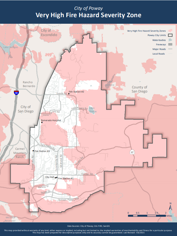
A large area of Poway is located within the Very High Fire Hazard Severity Zone (VHFHSZ) indicating its threat by wildland fire. Poway experiences a semi-arid climate (Köppen climate classification BSh) and is prone to experience extreme gusts of the Santa Ana’s coming off the foothills just east of Poway. The city is at serious risk of wildfire due to its terrain, with steep mountainous slopes and valleys; a warm, dry climate; and highly flammable chaparral vegetation. For this reason, a comprehensive strategy for reducing the risk of wildfire is necessary. This strategy includes the creation of defensible space by clearing highly flammable chaparral vegetation around structures, and the Vegetation Management Program, involving the removal of weeds and dry grasses from private property.
The City of Poway adopts by reference the International Fire Code and the California Fire Code. Local amendments are included in the triennial adoption process that address Poway’s unique climatic, geologic, and topographic characteristics. This adoption creates Poway’s Fire Code within the Poway Municipal Code. The Poway Fire Code is submitted for filing to the Building Standards Commission. Fire Prevention staff applies additional code requirements and fuel modification requirements to new construction projects in these areas. Vegetation management programs applied to existing parcels is managed by Code Compliance in consultation with staff from the Fire Prevention Division.
Fire History
Major portions of the town were evacuated during both the 2003 Cedar Fire and 2007 Witch Creek Fire. These two significant fires were part of historical fires in San Diego County. In recent years, local air support and mutual aid assistance has increased significantly. This has helped to prevent small vegetation fires spreading to become out of control wildland fires.


The 2003 Cedar Fire
The Cedar fire started at 5:37pm on October 25, 2003 and became a massive wildfire that burned 273,246 acres in the county during October and November. The rapid growth was driven by the Santa Ana winds which caused the fire to spread at a rate of 3,600 acres per hour. The Cedar Fire destroyed 2,820 buildings, including 2,232 homes, and killed 15 people, including one firefighter. The fire was brought fully under control on Dec 5, 2003. The Cedar fire remains one of the largest wildfires in California history and prior to 2018 was the third-largest wildfire in the state’s modern history. In Poway, the Cedar Fire destroyed 53 residential units, one business and burned 7,000 acres.
The 1967 Fire
A late October fire that began in Ramona, the 1967 fire burned many acres in San Diego County. During the fires 26 buildings were destroyed, including 16 homes in Poway. Schools and hundreds of people were evacuated. During this fire, 300 Poway High School students were pressed into service as firefighters when the fire threatened to surround the school. In addition to the buildings lost, hundreds of livestock died because of this fire.
The Witch Creek Fire of 2007
The Witch Creek Fire which started at 12:35pm October 21, 2007, in Witch Creek near Santa Ysabel. As with the Cedar fire, this fire also spread quickly due to strong Santa Ana winds. The fire merged with the Poomacha Fire which was near Palomar Mountain and then with the McCoy Fire. During its duration, 80–100 feet-high flames were reported, and characteristics of a firestorm were displayed at its height. As of 2018, the Witch Fire was the ninth-largest wildfire in modern California history, as well as the fifth-most destructive wildfire on record in California. A total of 7,247 acres and 90 homes were destroyed within the City of Poway, and of the approximate 211 homes within High Valley, 27 homes were lost.
Firefighting Resources
The Poway Fire Department is an all-hazard, all-risk response agency. From three fire stations, 17 personnel respond to emergency and non-emergency calls for service by staffing three paramedic engines, a paramedic ladder truck, two paramedic ambulances and one incident commander (Fire Battalion Chief).
The Poway Fire Department has been classified as a Class 1/1X department by the Insurance Services Organization’s Public Protection Classification program. ISO’s Public Protection Classification program measures and evaluates the effectiveness of fire-mitigation services in communities throughout the country. There are three, strategically located fire stations around the clock. Each fire station is maintained to ensure that firefighters are in a constant state of readiness and can quickly respond.
Collaboration with Key Partners
Poway Neighborhood Emergency Corps (PNEC)
Poway Neighborhood Emergency Corps (PNEC) is a 501(c)(3) nonprofit organization focused on disaster preparedness education. We provide outreach activities and educational programs to better prepare community members for emergencies and disasters such as wildfires, earthquakes, and floods.
PNEC is an all-volunteer organization and is not part of the City of Poway. However, PNEC works closely with the Poway Fire Department and serves only as an educational outreach organization as it relates to fire and wildfire safety and prevention.
The Poway Neighborhood Emergency Corps was established in 2011 after a group of residents identified the need for the community to be better prepared and informed regarding wildfire and other emergencies.
PNEC has been hosting and providing community workshops and events on emergency preparedness since its inception and has steadily grown outreach activities and collaborations. PNEC established its 501(c)(3) status in 2018.
City of Poway
The city supports disaster preparedness with an active, full-time Disaster Preparedness Coordinator on staff. The PNEC President and the Disaster Preparedness Coordinator work closely together.
The city’s general mission is to enrich the community and the quality of life through an exceptional blend of recreation, arts, leisure, and cultural programs, and to provide parks/facilities and open space for all.
Poway Fire Department
Maintains three strategically located fire stations around the clock. Each fire station is maintained to ensure that firefighters are ready and can respond. Poway’s fire training facilities are used by outside fire departments for training.
San Diego County Regional Fire Safe Council
Helps residents protect their families and homes from wildfire. Provides programs and services to respond and promotes fire safety and prevention while encouraging family involvement.
Community Emergency Response Team (CERT)
CERT program educates volunteers on disaster preparedness for disasters that may impact their community and trains them in basic disaster response skills such as fire safety, light search and rescue, team organization and disaster medical operations.
San Diego Sheriff's Department
The City of Poway has contracted with the San Diego County Sheriff’s Department (SDSO) since incorporation. The City of Poway is one of nine municipalities that contract for law enforcement services from the SDSO. Poway maintains a facility, the San Diego Sheriff’s Poway Station, staffed with sworn, civilian, reserve and volunteer personnel. The Poway Station is managed by a Captain with assistance from a Lieutenant.
Poway Auxiliary Communications Team (PACT)
PACT consists of Ham Radio enthusiasts from Poway and the surrounding area. PACT members communicate via Ham Radio on a weekly basis to ensure their readiness to respond to emergencies. PACT members will report to the City’s Emergency Operations Center (EOC) in the event of a significant emergency. PNEC collaborates with PACT and other agencies and groups to train and license Ham Radio operators with the goal of providing key information during emergencies.
Community Engagement & Education
Knowing what to do and how to stay safe in the event of an emergency is the responsibility of individuals, families, and businesses alike. The City of Poway offers resources on what you need to do to be prepared and how you can be involved in your community preparedness efforts.
The Poway Neighborhood Emergency Corps provides community outreach and education programs and activities related to emergency and wildfire safety prevention and preparedness. PNEC is an all-volunteer 501(c)(3) organization, not affiliated with the City of Poway. However, PNEC does work closely with the Poway Fire Department and serves only as an educational outreach organization as it relates to Fire Safety and Prevention in the community.
PNEC provides ongoing community education to ensure that citizens are aware of the critical preparedness information.
Priorities
- Education and preparedness for the local community
- Assistance services when an active emergency situation is present in the community.
- Ongoing evaluation of how the organization is responding to calls from the community.
- To assist community members with information to help them improve their homes and property regarding fire safety.
- To assist the elderly and other community members who may need assistance to achieve structural hardening for their home, property, and/or building structures.
Future Projects
- Continue to attend community events in educating the public on the importance of defensible space, hardening structures, knowing evacuation routes, registering for Alert San Diego, and preparing a 72-hour emergency ‘go-kit’.
- Provide training opportunities to PNEC members to enhance their disaster preparedness.
- Utilize social media to share preparedness messages and increase community engagement.
- Host quarterly meetings to share important information with the community on disaster preparedness and wildfire safety.
Structural Hardening
The City of Poway supports structural hardening in the Very High Fire Hazard Severity Zone (VHFHSZ) through adoption of the Fire Code. PNEC and the FSC will enhance those efforts by providing education on structural hardening best practices and connecting homeowners with resources.
Priorities
- Coordinate with the Poway Fire Department, Poway Planning Department, and State Fish and Wildlife Services to ensure projects meet the intent of the Poway Subarea Habitat Conservation Plan.
- Assist community members with information to help them improve their homes and property regarding fire safety including how to assess their homes vulnerability to wildfire.
- Assist elderly, low-income, and other qualifying community members to achieve structural hardening for their home, property and/or building structures.
Future Projects
- Provide training to homeowners on how to assess the vulnerability of a structure to wildfire and identify necessary structural hardening improvements.
- Create and maintain list of qualified/licensed vegetation management and/or fire resistive building construction contractors that may perform work within the City.
- Develop a program to fund and provide training for structural hardening projects for elderly, low-income, or other qualifying homeowners within the City. Projects may include the direct funding of materials such as ember resistive vents or the funding of specialized labor for the retrofitting of existing structures in the VHFHSZ.
Defensible Space
The creation of defensible space around structures is an important part of the comprehensive strategy to lessen the devastating impacts of wildfire and enhance firefighter safety. The City of Poway has codified defensible space requirements. PNEC and the FSC will enhance those efforts by providing education on defensible space and connecting homeowners and resources.
Priorities
- Coordinate with the Poway Fire Department, Poway Planning Department, and State Fish and Wildlife Services to ensure projects meet the intent of the Poway Subarea Habitat Conservation Plan.
- Assist community members with understanding and meeting Poway Municipal Code Chapter 8.76 Defensible Space, Vegetation Management, and Waste Accumulations.
- Assist elderly, low-income, and other qualifying community members to achieve adequate defensible space including the thinning or removal of vegetation and the planning of fire resistive vegetation.
Future Projects
- Identify opportunities for providing chipping or other debris removal services to landowners or caretakers within the City.
- Develop a program to provide landowners with timely, accurate data regarding the defensible space needs and wildfire risk associated with their parcel.
- Develop a program to fund defensible space projects for elderly, low-income, or other qualifying homeowners within the City. Projects may include the direct funding and training of defensible space activities including thinning, pruning, mowing, or crushing of vegetation by vendors, licensed contractors, or volunteers.
Evacuation Planning
- Poway Road
- Espola Road to Rancho Bernardo Road
- Scripps Poway Parkway
- Ted Williams Parkway
- Pomerado Road
- Interstate 15
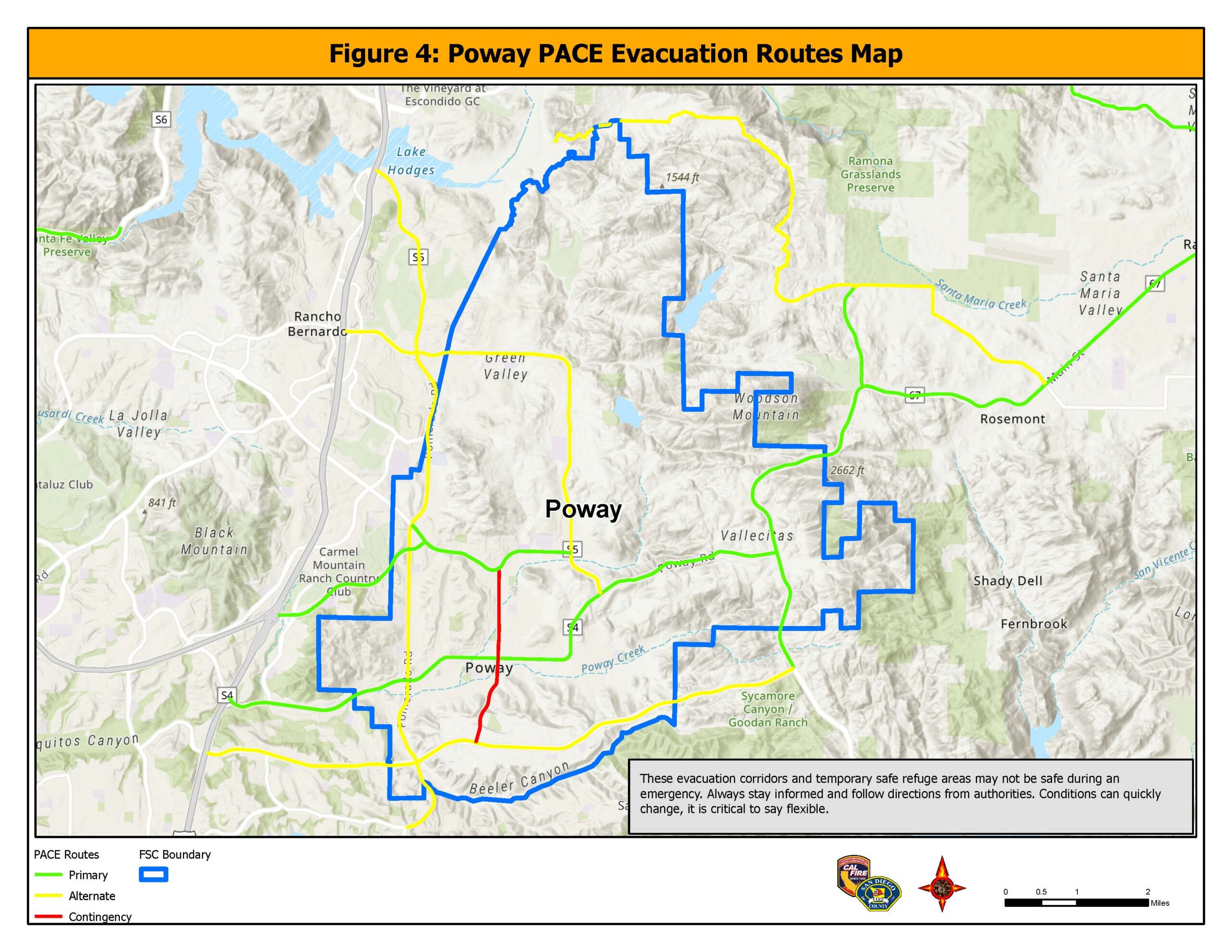
Designated Evacuation Corridors and Temporary Safe Refuge Areas (TSRA)
The City of Poway, in partnership with the American Red Cross, has identified nine schools, churches, and community centers as authorized evacuation sites and overnight shelters. These are predetermined sites with adequate areas to put down cots for sleeping. These facilities also have adequate restrooms. Residents are not assigned to an evacuation site in advance of the emergency. Due to the unpredictable nature of wildland fires, evacuation sites will be selected at the time of the emergency. Residents will be notified by reverse 9-1-1 calls, social media and the media of open shelter sites and or Temporary Evacuation Points (TEP) as needed.
Approximately 100 staff and local volunteers have been trained in Shelter Operations to augment the staffing of evacuation shelters when needed.
Temporary Evacuation Points are not predetermined sites. These are established by the Sheriff’s Department at the moment of an evacuation. TEP’s are intended to immediately evacuate neighborhoods and have a safe location for people to gather and receive additional information. If residents cannot return home for an extended period, they will then be directed to overnight shelters. A TEP can be a parking lot, shopping center of House of Worship, or any other safe place the Sheriff chooses at the time.
A Temporary Safe Refuge Area (TSRA) is a large open area residents can go to if their primary or alternate routes become suddenly impassable. Poway has identified approximately 9 of these open space areas, with adequate parking and restroom facilities, that residents could use during an emergency to shelter in place. These areas are identified on the Poway PACE map.